Different types of records to maintain Land records (భూమి రికార్డులను నిర్వహించడానికి వివిధ రకాల రికార్డులు)
Sethwar: A register of land survey details and graduates for the first time by revenue villages. It was in force until 1953. Later Khasra Pahani became available.
సేత్వార్
: రెవెన్యూ గ్రామాల వారీగా మొదటి సారి చేసిన భూమి సర్వే వివరాలు,
పట్టాదారుల వివరాలు తెలిపే రిజిస్టర్. ఇది 1953 దాకా అమలులో ఉంది. తర్వాత
ఖాస్రా పహాణీ అందుబాటులోకి వచ్చింది.
Diglot:
After completing the survey settlement activities in every village in
the state and registering the details of lands in each village,It
contains all types of land survey numbers, acreage, Sarkara, Inam lands,
Magania, Metta, their classification, discipline, etc.This register is
written in English and Telugu. That is why it is called 'Diglot'. This
is considered a permanent 'A' register. This register is like a pillar
for all other village revenue records. Permanent A-Register printed in
Telugu and English. It is using the same AP as Sethwar.
డైగ్లాట్ : రాష్ట్రంలోని ప్రతి గ్రామంలో సర్వే సెటిల్మెంట్ కార్యకలాపాలు పూర్తి
చేసి ప్రతి గ్రా మంలో భూముల వివరాలు నమో దు చేస్తా రు. ఇందులో అన్ని రకాల
భూ ముల సర్వే నెంబర్లు ,విస్తీర్ణం, అవి సర్కారా, ఇనాం భూములా, మాగా ణియా,
మెట్టా, వాటి వర్గాకరణ, శిస్తు, మొదలగు వివరాలు ఉం టాయి. ఈ రిజి స్టర్ను
ఇంగ్లిష్లో, తెలుగులో రాస్తారు. అందకే దీనికి ‘డైగ్లాట్’ అంటారు. దీనినే
శాశ్వత ‘ఏ’ రిజిస్టర్గా పరిగణిస్తారు. ఈ రిజిస్టర్ మిగతా గ్రామ రెవెన్యూ
రికార్డులన్నింటికీ మూలస్తంభం లాంటిది. తెలుగు, ఇంగ్లిఫ్ భాషల్లో ముద్రించిన శాశ్వత ఏ-రిజిస్టర్. ఇది సేథ్వార్ మాదిరిగానే AP లో ఉపయోగిస్తోంది.
Re Settlement Register (RSR):
This is the same basis for government land acquisition for public use. The RSR registers contain details such as government land, private land (individuals), Eenam lands, Devadaya, Waqf lands, ditches and bends. This information is available at the VRO, Tehsildar, RDO offices as well as at the district level AD office.
- రీ సెటిల్మెంట్ రిజిష్టర్ (ఆర్ఎస్ఆర్) :
ప్రజా అవసరాల కోసం ప్రభుత్వం భూమి సేకరణకు ఇదే ఆధారం. ఆర్ఎస్ఆర్
రిజిష్టర్ల్లో ప్రభుత్వ భూమి, ప్రైవేట్ భూమి(వ్యక్తులు), ఈనాం భూములు,
దేవదాయ, వక్ఫ్ భూములు, వాగులు, వంకలు లాంటి వివరాలు ఉంటాయి. ఈ సమాచారం
వీఆర్ఓ, తహసీల్దార్, ఆర్డీఓ కార్యాలయాలతోపాటు జిల్లా స్థాయిలో ఏడీ
కార్యాలయంలో ఉంటాయి.
Sethwar,Diglot,Re Settlement Register are the base records for all land in Telagana and Andhra.
సేత్వార్, డిగ్లోట్, రీ సెటిల్మెంట్ రిజిస్టర్ తెలగాణ మరియు ఆంధ్రాలోని అన్ని భూములకు మూల రికార్డులు.
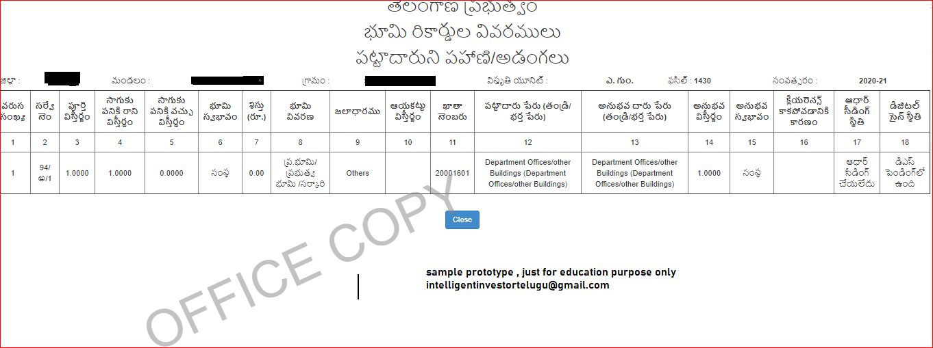
పహానీ: భూమి యాజమాన్యపు హక్కు రికార్డు. దీన్ని కోస్తాలో ‘అడంగల్’ అంటారు. రెవెన్యూ రికార్డుల్లో మూడోనంబర్ రిజిష్టర్ను పహానిగా పిలుస్తారు. ఇందులో 18 కాలమ్స్ ఉంటాయి. భూమికి సంబందించిన సాధికారిక చరిత్ర మొత్తం ఇందులో ఉంటుంది. ఇది ప్రభుత్వం అధికారికంగా ధ్రువీకరించే రికార్డు. భూముల అమ్మకాలు కొనుగోళ్లు, సాగు చేస్తున్న పంట వివరాలు ఎప్పటికప్పుడు ఇందులో నమోదు చేస్తారు. ప్రతి సంవత్సరం ఒక పహానీ తయారు చేస్తారు.
Pahani: Land ownership record. This is called ‘Adangal’ on the coast. The number three register in the revenue records is called the pahani. It contains 18 columns. It covers the entire history of land empowerment. This is a record officially certified by the government. Land sales, purchases and crop details are recorded from time to time. A pahani is made every year.
Revenue Terminology ( రెవెన్యూ పరిభాష )
Land types ( వివిధ భూముల రకాలు)
ఆయకట్టు : ఒక నీటి వనరు కింద సాగయ్యే భూమి మొత్తం విస్తీర్ణాన్ని ఆయకట్టు అంటారు.
Ayakattu: Ayakattu is the total area of land that stretches under a body of water.
అసైన్డ్భూమి : భూమిలేని నిరుపేదలు సాగు చేసుకునేందుకు, ఇండ్లు నిర్మించుకునేందుకు ప్రభుత్వం మంజూరు చేసిన భూమి. దీనిని వారసత్వ సంపదగా అనుభవించాల్సిందే తప్ప ఇతరులకు అమ్మడం, బదలాయించడం కుదరదు.
Assigned land : The land granted by the government to cultivate and build houses for the poor without land. This should be experienced as a inheritance, butcannot be sold and replaced by others.
గ్రామ కంఠం(ఆబాదీ) :గ్రామంలో నివసించేందుకు కేటాయించిన భూమిని గ్రామ కంఠం అం టారు. ఇది గ్రామానికి చెందిన ఉమ్మడి స్థలం. ఇందులో ప్రభుత్వ సమావేశాలు, సభలు కూడా ఏర్పాటు చేసుకోవచ్చు. గ్రామ కంఠం భూ వివరాలు పంచాయతీ రికార్డుల్లో ఉంటాయి.
Village Throat or Village Voice:The land that is allotted to the residents of the village is called village Kantham. This is a joint place of the village. Government meetings and meetings can also be arranged in this. Village Kantham land details will be in Panchayat records.
HMDA సైట్ నుండి నమూనా గ్రామ కంఠం, అవి బ్లాక్ బాక్సులుగా గుర్తించబడతాయి
Sample Village Throat from HMDA site,they idenfy as black boxes బంజరు భూమి (బంచరామి) : గ్రామం, మండల పరిధిలో ఖాళీగా ఉండి ప్రజావసరాల కోసం ప్రభుత్వం నిర్దేశించిన భూమి. దీనిని రెవెన్యూ రికార్డుల్లో ప్రత్యేక గుర్తులతో సూచిస్తారు.
Banjaru land (Bancharami):The land that was empty in the limits of the village and mandal, for the sake of the people's needs, was directed by the government. This is referred to as special signs in revenue records.
దేవళ్ ఇనాం : దేవాలయ ఇనాం భూమి. దేవాలయాల నిర్వహణ కోసం పూజారుల పేరునగానీ, దేవాలయం పేరున కేటాయించిన భూమి.
God's gift: The land of the temple. Land allotted in the name of priests and temple for the management of temples.
ఇనామ్: సేవలను గుర్తించడం ద్వారా ప్రభుత్వం ఇచ్చిన భూమి
Inam: Land given by government by identifying services
బాలోతా ఇనాం : భూమిలేని నిరుపేద దళితులకు ప్రభుత్వం ఇచ్చే భూమి
Balota Inam: Land given by the government to the landless poor Dalits
పోరంబోకు : భూములపై సర్వే చేసే నాటికి సేద్యానికి పనికిరాకుండా ఉన్న భూములు. ఇది కూడా ప్రభుత్వ భూమే.
Poramboku: Lands that are not suitable for cultivation as surveyed. It is also government land.
అగ్రహారం : పూర్వకాలంలో బ్రాహ్మణులకు శిస్తు లేకుండా తక్కువ శిస్తుతో ఇనాంగా ఇచ్చిన గ్రామం లేదా అందులోని కొంత భాగాన్ని అగ్రహారం అంటారు.
Agraharam : In the past, the village which was given to the Brahmins with less discipline without discipline or some of it is called Agraharam.
సర్ఫేఖాస్ : నిజాం నవాబు సొంత భూమి
Sarfekhas: Nizam Nawab's own land
బేవార్స్ : హక్కుదారు ఎవరో తెలియకపోతే దాన్ని బేవార్స్ భూమి అంటారు.
Beavers: If the claimant does not know who it is, it is called Beavers land.
ఇస్తిఫా భూమి : పట్టదారు స్వచ్ఛందంగా ప్రభుత్వపరం చేసిన భూమి
Istifa land: Land voluntarily given to government-owned by citizens
ఇనాం దస్తర్దాన్ : పొగడ్తలకు మెచ్చి ఇచ్చే భూమి
Inam Dastardan: Land of compliments
తరి : సాగు భూమి
Tari: Cultivated land
ఖుష్కీ : మెట్ట ప్రాంతం
Dry: Metta area
గెట్టు : పొలం హద్దు
Gettu: Farm boundary
కౌల్దార్ : భూమిని కౌలుకు తీసకునేవాడు
Kauldar: A person who leases land
కబ్జాదార్ : భూమిని తన ఆధీనంలో ఉంచుకుని అనుభవించే వ్యక్తి
Occupier: A person who enjoys keeping the land under his control
కమతం : భూమి విస్తీర్ణం
Lot: Land area
ఇలాకా : ప్రాంతం
Location: Area
కాస్తు : సాగు చేయడం
Costtu: Cultivation
సీలింగ్ : భూ గరిష్ఠ పరిమితి
Ceiling: Land ceiling
అబి : వానకాలం పంట
Abi: Rainy season crop
శిఖం : చెరువు నీటి నిల్వ ఉండే ఏరియా విస్తీర్ణం
Shikham: Pond is the area where water is stored
దో ఫసల్ : రెండు పంటలు పండే భూమి
Do Fasal: Land with two crops
ఫసలీ : జులై 1నుంచి 12 నెలల కాలన్ని ఫసలీ అంటారు.
Fasali: The period from July 1 to 12 months is called Fasali.
సర్వే నంబర్ : భూముల గుర్తింపు కోసం కేటాయించేది
Survey Number: Allocated for land identification
నక్షా : భూముల వివరాలు తెలిపే చిత్రపటం
Map: A map showing the details of the land
ఎన్కంబరెన్స్ సర్టిఫికెట్ (ఈసీ) : భూ స్వరూపాన్ని తెలియజేసే ధ్రువీకరణ పత్రం. 32 ఏళ్లలోపు ఓ సర్వే నంబర్ భూమికి జరిగిన లావాదేవీలను తెలియజేసే దాన్ని ఈసీ అంటారు.
Encumbrance Certificate (EC): Certificate of land tenure. A survey number under the age of 32 is known as Easy, which describes the transactions that have taken place on the land
ఫీల్డ్ మెజర్మెంట్ (ఎఫ్ఎంబీ) బుక్ : దీన్నే ఎఫ్ఎంబీ టీపన్ అని కూడా అంటారు. గ్రామ రెవెన్యూ రికార్డుల్లో ఎఫ్ఎంబీ ఒక భాగం. ఇందులో గ్రామంలోని అన్ని సర్వే నంబర్లు, పట్టాలు, కొలతలు ఉంటాయి.
Field Measurement (FMB) Book: Also Known As FMB Teapon. FMB is a part of village revenue records. It contains all the survey numbers, rails and measurements of the village.
పట్టాదారు పాస్ పుస్తకం : రైతుకు ఉన్న భూమి హక్కులను తెలియజేసే పుస్తకం.
Graduate Pass Book: A book that informs the farmer about his land rights.
బందోబస్తు : వ్యవసాయ భూములను సర్వే చేసి వర్గీకరణ చేయడాన్ని బందోబస్తు అంటారు.
Provision: Survey and classification of agricultural lands is called provision.
బీ మెమో : ప్రభుత్వ భూమిని ఆక్రమించుకుని సాగు చేసుకుంటున్న వ్యక్తి శిస్తు, జరిమానా చెల్లించాలని ఆదేశించే నోటీస్ను బీ మెమో అంటారు.
B Memo: A notice instructing a person occupying and cultivating government land to pay discipline and a fine is called a B memo.
ఫైసల్ పట్టీ : బదిలీ రిజిస్టర్
File List: Transfer Register
చౌఫస్లా : ఒక రెవెన్యూ గ్రామంలో ఒక రైతుకు ఉన్న వేర్వేరు సర్వేనంబర్ల భూముల పన్ను ముదింపు రికార్డు.
Chaufasla: Land tax assessment record of different surveyors per farmer in a revenue village.
విరాసత్/ఫౌతి : భూ యజమాని చనిపోయిన తర్వాత అతడి వారసులకు భూమి హక్కులు కల్పించడం.
Inheritance / Fouthi: Granting land rights to the land owner after death.
మింజుములే : మొత్తం భూమి.
Minjumule: The whole area.
మార్ట్గేజ్ : రుణం కోసం భూమిని కుదవపెట్టడం.
Mortgage: Land grabbing for a loan.
మోకా : క్షేత్రస్థాయి పరిశీలన(స్పాట్ఇన్స్పెక్షన్).
MOOCA: Field inspection (spot inspection).
టైటిల్ డీడ్ : భూ హక్కు దస్తావేజు, దీనిపై ఆర్డీవో సంతకం ఉంటుంది.
Title: Deed: Land title deed signed by RDO
ఆర్వోఆర్ (రికార్డ్స్ ఆఫ్ రైట్స్) : భూమి యాజమాన్య హక్కుల రిజిస్టర్.
ROR (Records of Rights): Register of Land Ownership.
ఆర్ఎస్సార్ : రీ సెటిల్మెంట్ రిజిస్టర్ లేదా శాశ్వత ఏ రిజిస్టర్.
RSR: Resettlement Register or permanent register.
పర్మినెంట్ రిజిస్టర్ : సర్వే నంబర్ల వారీగా భూమి శిస్తులను నిర్ణయించే రిజిస్టర్. సేత్వార్ స్థానంలో దీన్ని ప్రవేశపెట్టారు.
Permanent Register: A register that determines land discipline by survey numbers. It was introduced in place of Sethwar.
సాదాబైనామా : భూ క్రయ విక్రయాలకు సంబంధించి తెల్లకాగితంపై రాసుకొనే ఒప్పంద పత్రం.
Plain name (Sadabainama): A contract document written on white paper in connection with the sale of land.
దస్తావేజు : భూముల కొనుగోళ్లు, అమ్మకాలు, కౌలుకు ఇవ్వడం లాంటి ఇతరత్ర లావాదేవీలను తెలియజేసే పత్రం.
Document(Bond Paper): A document informing other transactions such as purchase, sale and lease of land.
నాలా : వ్యవసాయేతర భూమి
Nala: Non-agricultural land
గైరాన్ : సామాజిక పోరంబోకు
Giron: Social Poramboku
యేక్రార్నామా : ఇరు గ్రామాల పెద్దల నుంచి సర్వేయర్ తీసుకునే గ్రామాల ఒప్పందం
Agreement (Yekranama): Village agreement to be taken by the surveyor from the elders of the two villages